Tides and Tide Prediction
This tide and tide prediction resource directory links to online tide
predictors, tide observations/sea level measurements, tide prediction software
you install to generate tide predictions on demand, and general information on
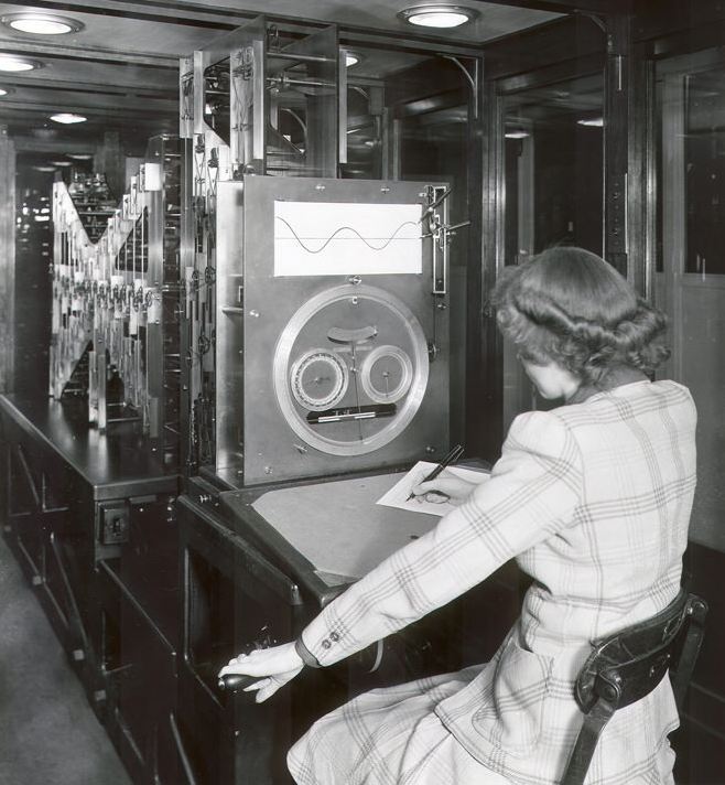
tides and tide prediction. Before computers and software, machines, like the one
at left, generated tide predictions.
Tides are the alternating rise and fall of sea level with respect to land, as
influenced by the gravitational attraction of the moon and sun. Other factors
influence tides; coastline configuration, local water depth, seafloor
topography, winds, and weather alter the arrival times of tides, their range,
and the interval between high and low water.
A tide prediction can differ from
the actual sea level that will be observed as a result of the tide. Predicted
tidal heights are those expected under average weather conditions. For accuracy of tide predictions, see
Tide Prediction Error for the United States Coastline. When weather
conditions differ from what is considered average, corresponding differences
between predicted levels and those actually observed will occur. Generally,
prolonged onshore winds (wind towards the land) or a low barometric pressure can
produce higher sea levels than predicted, while offshore winds (wind away from
the land) and high barometric pressure can result in lower sea levels than
predicted. Thus mariners need to take local conditions into account when
considering critical activities with tide prediction information.
When looking at tide predictions, watch out for daylight savings time if applicable locally to the site of the predictions.
Do the tide predictions adjust for daylight savings time? Some play out their
predictions only in standard time, so be sure to adjust accordingly if applicable.
In the U.S., daylight savings starts 2nd Sunday in March & ends first Sunday in November.
These predictors have worldwide or very large area coverage.
- Annuaire des Marees for a seven day window for western
Europe [maree.info]
- EasyTide for a seven day
window for United Kingdom [British Admiralty]
- NOAA Tide Predictions for
the United States and its territories [NOAA]
- Tidal Predictions for UK and Irish Ports for
a four week window for the UK and Ireland, one year for British territories, South Atlantic, and Gibraltar [National Oceanography Centre]
- Tide Predictions for Australia, South Pacific & Antarctica for
a seven day window [National Tidal Centre, Australia]
- Tides and Solunar Tables for a six month window for the
United States and its territories [TidesSolunar.com]
- Tides, Currents, and Water Levels for a seven day window
for Canada [F&OC]
- Tides Tables / Calcul de la Maree for a seven day window for the
world. [SHOM France]
- Tideschart for a seven day window for the
world. Includes IOS and Android apps. [Ryan Blundell]
- WWW Tide and Current Predictor for various time
periods up to two years for the world [D Pentcheff, D Flater]
- www.saltwatertides.com for a two week window for twelve months
ahead for the US East Coast, Gulf Coast, and West Coast -- includes sun rise/set and moon rise/set/phase [www.saltwatertides.com]
Predictors of Local Interest to San Diego:
Actual sea level measurements -- tide predictions are calculated
estimates of sea level whereas observations measure the actual sea level that occurred
- PORTS (Physical
Oceanographic Real-Time System) provides real-time data for tides, tidal
currents, density, water temperature, wind, air temperature & pressure for
Chesapeake Bay, Houston/Galveston, New York/New Jersey, San Francisco,
Narragansett Bay, & Tampa Bay [NOAA NOS CO-OPS]
- Water Levels offers
near real-time water level observation data and plots comparing predictions to observations
[NOAA NOS CO-OPS]
TIDE PREDICTION SOFTWARE
not a complete list |
- Admiralty TotalTide [Win; worldwide coverage, PC Maritime]
- JTides Win/Mac/Android; US/worldwide coverage, P Lutus]
- NAO.99b [Unix; worldwide coverage, K Matsumoto]
- Neptune Tides [Win/Android; UK/Europe coverage, Neptune Navigation Software]
- Tide Plotter [Win; UK, Ireland, Europe, East Coast US, Australia coverage, Belfield Software]
- TideComp [Win; worldwide coverage, Pangolin]
- Tides [DOS; worldwide coverage, Stormy Weather Software]
- Tides [DOS, Edward Wallner]
- Tideschart [IOS and Android apps; worldwide coverage, [Ryan Blundell]]
- Tide.1 and World.Tide [DOS; US and worldwide coverage respectively, Micronautics]
- WTides [Win; worldwide coverage, P Thornton]
- XTide [Unix; worldwide coverage, D Flater]
- XTide ported to other operating systems
- tide apps in the Apple store for iPhone/iPad
© Peter Brueggeman. First published in July 1997.
peterbman(at)gmail.com
Photo: Woman professional operating tide prediction machine. Washington, DC, 1944.
Credit: Association of Commissioned Officers. NOAA Historical Photo Collection